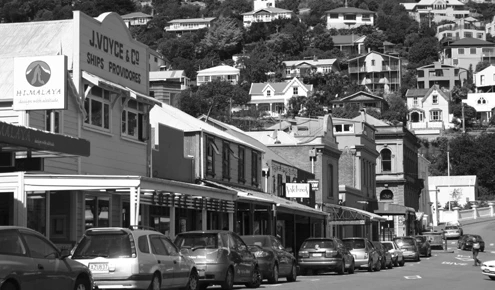
Historic Lyttelton Harbour

While the earthquakes of 2010 & 2011 did destroy most of the historic brick buildings in Lyttelton, there is still much that has remained and been rebuilt. Come and explore this quaint colonial seaside settlement.
A little history of Lyttelton
The earliest evidence of human presence in the area is moa bones dating from roughly 1250. The Maori who lived here for some 700 years before European discovery called Lyttelton Te whaka raupo. In 1770 Captain James Cook on his first Endeavour expedition named the peninsula Banks Island after his trusty botanist Joseph Banks. It was one of only two mistakes Cook made in his cartography of the south island and the error wasn’t rectified until a Captain Chase tried to sail between the ‘island’ and mainland in 1809. See Cook’s map:https://teara.govt.nz/en/zoomify/19330/cooks-map-of-new-zealand
After Captain Cook, came the whalers and then the French, who settled a colony in 1840 at Akaroa (a charming town that still bears French street names today) having been beaten to the colonisation of the area by British by just one month.
In August 1849 Lyttelton was officially proclaimed a port in preparation most likely for the arrival of the Canterbury Association, which was to lead the colonization of Christchurch.
George William Lyttelton led the association, which was Anglican and optimistic. In 1850 the four ships arrived, the Randolph, Cressy, Sir George Seymour and Charlotte Jane (locals will be very impressed if you can reel off these names) bringing the first of the ‘Canterbury pilgrims’ as they came to be known. Exactly 3,549 settlers arrived in Lyttelton in the first three years. Of these, 400 were land purchasers, and the rest were mostly labourers and servants. Christchurch was gradually established, the pilgrims originally carrying their worldly possessions up and over the Bridle Path, which is still a steep walk today. For more colonial history see http://www.teara.govt.nz/en/canterbury-region
For those who like important dates amongst us:
1851 – The Lyttelton Times published up until 1929 when it became the Christchurch Times.
1867 – The rail tunnel opened
1877 - The Lyttelton Harbour Board, now Port Lyttelton Company, developed the inner harbour. For information about the port and webcams see http://www.lpc.co.nz
1862 – First telegraph transmission in NZ made from Lyttelton Post Office.
1870 – Fire destroyed all the wooden buildings in Norwich Quay.
1876 – The castle-like Timeball station was built. Now a museum, it remains one of just five remaining working Timeball stations in the world – the Timeball is still dropped at precisely 1pm daily.
1908 – Shackleton's British Antarctic Expedition
1964 – Road tunnel opened between Lyttelton and Christchurch.
1996 – Peter Jackson’s film The Frighteners filmed in Lyttelton.
2005 – Banks Peninsula residents voted in favour of amalgamating with Christchurch City Council. By 2009, Lyttelton’s aged water pipe system was being replaced, roads were upgraded and London Street was given a major makeover that included some controversial footpath pavers (the footpath had historically been asphalt).
2009 – Lyttelton township listed as an Historic Area on the Historic Places Trust register.
2010-2011 - Christchurch & Lyttelton Earthquakes damage much of the town
Always gets a special mention because of the role it has played in Lyttelton’s history and because it sits in the middle of the harbour and is consequently visible from most of Lyttelton’s lounge room windows, and because locals are quite fond of it.
From the 1880s Quail Island was a quarantine station, for people and then animals. In 1901 and 1910, the island housed dogs and ponies destined for British Antarctic expeditions. Between 1918 and 1925 it was a leper station. Now a reserve, it is being replanted with native vegetation.
Otamahua/Quail Island Ecological Trust: http://www.quailisland.org.nz/
Catch a ferry to Quail Island: http://www.blackcat.co.nz/quailisland.asp.
Also see our Antarctic Brochure:
